
 File Photo
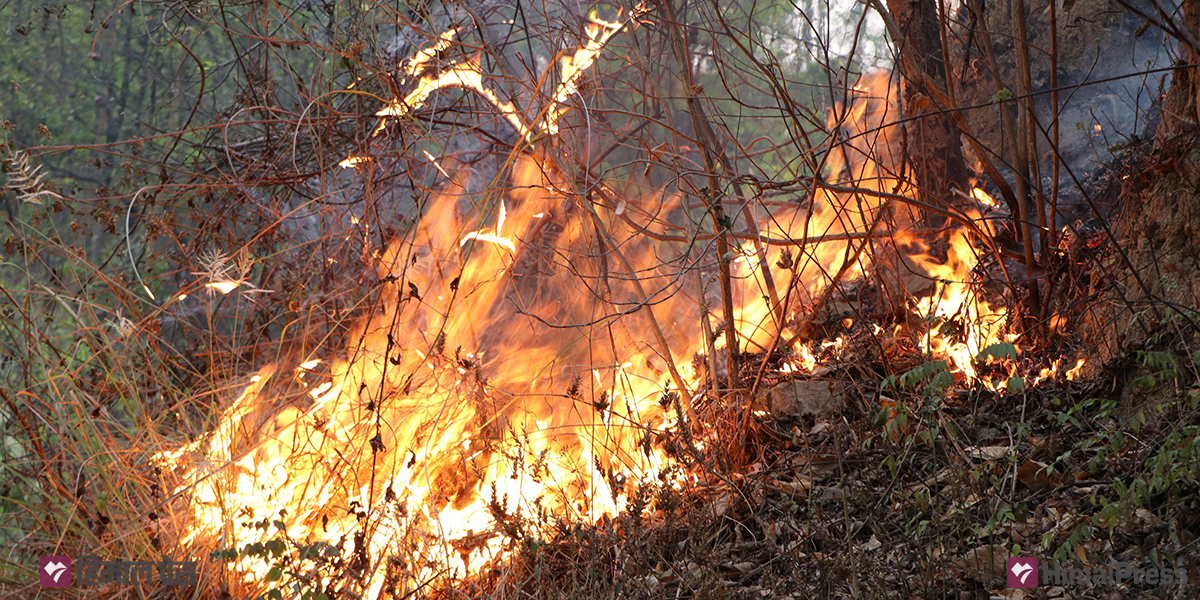
LUMBINI: Wildfires are becoming increasingly rampant in the forest areas of Lumbini Province.
Although awareness programs are being implemented on a regular basis, incidents of forest fires have been on the rise. In the last two weeks, fires have broken out in different community forests of Chure and Mahabharata ranges as well as the lowlands of the Tarai.
According to the Ministry of Forests, Environment, Tourism and Water Supply, Lumbini Province Government, wildfires have engulfed 4,377 hectares of forest area in Lumbini Province until mid-April of the current fiscal year. Mahale Gharti (58) of Musikot Municipality-1 of Gulmi died while trying to douse a fire in a pine forest on land owned by Sarbodaya Secondary School.
In Arghakhanchi, three houses and nine cowsheds were destroyed, and three buffaloes and seven goats died due to forest fires. Eight people were injured in Rukum East in fire incidents, according to Dilaram Paudel, a forest officer at the Ministry of Forests, Environment, Tourism, and Water Supply.
Paudel said that wildfires have been recorded in 124 locations across Lumbini Province, affecting 4,377 hectares of forest area. “There has been no significant damage, but the forest fires have caused damage to bushes, snakes, wildlife, and vegetation in Banke,” he said.
The Division Forest Office, Rupandehi, has reported fires in the Shivanagar and Charpala community forests in Butwal. More than 665 hectares of forest area have been affected by fires in Rupandehi alone. Sandip Basukala, Information Officer at the Division Forest Office, Rupandehi, said that a network has been set up in the fire-prone areas of Devdaha and Kanchan for proper coordination to control fire incidents. He added that rescue teams have also been prepared to control the fires. “The rescue teams have been mobilized with necessary equipment,” Basukala said.
Sarina KC of the Division Forest Office, Kapilvastu, said that fires have been regularly occurring at the same location in the Shivanagar Community Forest.
A wildfire in Wards 3 and 4 of Lumbini Sanskritik Municipality destroyed wheat crops planted on nearly 50 bighas (around 31 hectares) of land last week, affecting 50 farmers.
In Mayadevi Rural Municipality-2, Kapilvastu, a fire on Wednesday destroyed wheat crops planted on around three bighas of land. The fire broke out while harvesting was underway using a combined harvester. The harvester was also completely burnt in the incident. DSP Hari Oli, the spokesperson for the District Police Office, Kapilvastu, said that wheat crops on three bighas belonging to five farmers were destroyed by the fire.
In the Chure region, which stretches from Daunne in Nawalparasi West to Chisapani in Bardiya, 24 municipalities have been affected by forest fires. Most of the fires in these areas have been occurring in the forests located between the East-West Highway and the northern Bhavar and Chure regions. Wildfires break out in these areas every year.
Areas like Rapti Sonari in Banke, Rajapur, Babai, and Gadhawa in Dang, Shitganga in Arghakhanchi, Shivraj in Kapilvastu, Sunwal in Nawalparasi, Devdaha, and Saljhandi in Rupandehi are considered highly prone to forest fires.
Every year, the federal, provincial, and local governments spend millions of rupees to control forest fires. But authorities have been failing to control fire incidents on time. According to environmental expert Yuvaraj Kandel, the main reasons for this are the government’s urban-centric awareness programs and the declining ownership of the community in forests. “When fires break out in the jungles, people do not go to extinguish them. The community’s sense of ownership of forests is diminishing,” he said. “This is also contributing to the spread of forest fires.”
According to Kandel, in recent years, there has been a tendency among people to call fire engines or inform government agencies when fires break out instead of rushing to extinguish fire themselves. Kandel said that in Lumbini Province, wildfires that were once limited to the Chure range, have now spread to the Mahabharat range and are moving towards the Putha and Uttarganga peaks. “The bushes in the Chure and Mahabharat ranges have increased. Every year, fires seem to be spreading 5-7 kilometers upwards,” he added.
He believes that human negligence, rather than the need for fodder and firewood, has led to an increase in forest fires. He said that the excessive use of plastic along the East-West Highway has contributed to the spread of fires.
Fires in the forests along the highway are primarily caused by travelers, while in the Terai region, farmers themselves start fires in their fields. Travelers who stop in forested areas to relieve themselves often discard cigarette butts and inflammable materials which also cause forest fires.
Kandel suggests that local governments connect people with forests to control fires effectively. “Unless forests are linked to production, such as using forest bushes and fallen leaves as fertilizer or connecting them to other products, communities will not be engaged with the forests,” he added.
Experts say the local government should adopt measures such as mobilizing committees in local settlements and build ponds in forest areas, among others, to control wildfires.
Forest areas cover 423,617 hectares of land in 12 districts of Lumbini Province.


![Naubise-Nagdhunga tunnel formally inaugurated [With Pictures]](https://en.himalpress.com/wp-content/uploads/2026/07/WhatsApp-Image-2026-07-27-at-15.08.18.jpeg)