
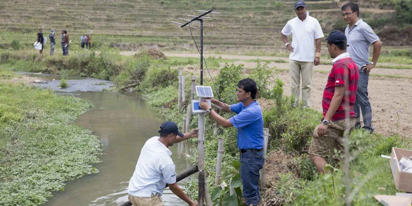
 In June 2015, staff from The International Centre for Integrated Mountain Development (ICIMOD) deliver training for a ‘community-based’ flood early warning system in Lalitpur, Nepal (Image: ICIMOD Kathmandu / Flickr, CC BY-NC)
When UN Secretary General António Guterres introduced the organization’s Early Warnings for All (EW4All) action plan in 2022, he added that: “Those who have contributed least to the climate crisis are the most at risk and the least protected.” In the Himalayan region, increased climatic volatility and the corresponding destabilization of the cryosphere – the frozen world above, which includes glaciers and permafrost – is creating new disaster risks and vulnerability. These changes are making the need for effective early warning systems (EWS) and climate justice particularly acute.
Several cascading disasters have occurred across the Himalayan region in recent years. A cascading disaster is when one disaster sets off, and adds to, another. In June 2021 Nepal saw the Melamchi disaster – where intense rainfall, a glacial lake outburst flood (GLOF), and river-blocking landslides created a massive debris-laden flood that devastated communities and the billion-dollar drinking water project that supplies Kathmandu. The deadly avalanche-triggered debris flow that destroyed two hydropower projects in India’s Uttarakhand district in February 2021 is another recent example.
Disasters like these serve as stark reminders that multi-hazard risk assessments are critical across the Himalayas. Over the past two years, I have been working with The Stimson Center to design and build new multi-hazard assessment and monitoring tools that can support EWS in Nepal. Our project aims to bring together cutting-edge earth observation tools with localized hazard data to understand and monitor the associated risks of cascading disasters.
Working with partners at the Institute of Himalayan Risk Reduction (IHRR) and People in Need (PIN) Nepal, we have learned a great deal about the shifting frontiers of hazard monitoring and how new modeling and earth-observation technologies are creating new Early Warning System (EWS) possibilities. At the same time, this work has reaffirmed our belief in the value of local data, community-engaged EWS, and the importance of integrating place-based knowledge.
According to Anil Pokhrel, the head of Nepal’s National Disaster Risk Reduction and Management Authority, more than $600 million is needed to develop a multi-hazard EWS program capable of country-wide coverage. Because funding to match these urgent needs is not readily available, there is a need to design low-cost and scalable solutions which can help expand EWS coverage in the Himalayas.
Satellite-based earth observation tools are critical to any such endeavor because they can help address chronic issues of data scarcity. The immensity of the Himalayan region and the logistical challenges of installing and maintaining weather observation stations in high-mountain regions make a comprehensive network of physical stations incredibly expensive. Instead, publicly available earth-observation data from programs like the European Space Agency’s Sentinel missions or the soon to be launched NISAR mission could complement, if not fully replace, the need for such an investment.
These new technologies, though, are most effective when combined with grounded observation—particularly in situations where analysts and algorithms are not always entirely sure what to look for. Localized knowledge and engagement are also essential for planning precise patterns of anticipatory action, which requires translating potential risks and alerts into a specific human context.
People-centered EWS in the Himalayan region
The value of people-centered EWS was a recurring theme at the recent National-Level Learning Sharing Workshop on Early Warning Systems in Kathmandu – a gathering of over 200 members from Nepal’s disaster risk reduction and EWS community. Sessions were organized around the UN Office for Disaster Risk Reduction’s (UNDRR) four “pillars” for effective EWS: disaster risk knowledge; monitoring and forecasting; dissemination and communication; and preparedness and response capabilities. Amid discussion of new techniques for modeling, impact-based forecasting, and alerting protocols, the value of localized data and the need to meaningfully engage at-risk communities was a common concern—central to all four pillars.
Meaningfully engaging local stakeholders and incorporating place-based knowledge is perhaps the best investment any EWS project can make. It increases data quality: resulting in a finer understanding of hazards, exposure, and situated vulnerabilities. It helps ensure EWS efficacy and impact by opening up lines of communication, encouraging a two-way exchange of data and creating space for adaptive EWS management and design. Such dialogue helps ensure locals can understand how they can respond to alerts and the risks that are identified by technology.
Earth-observation tools like synthetic-aperture radar (SAR) aid Stimson in our work to identify landform changes and model potential hazard chains. But to really understand the possible consequences for people, we need to understand what vulnerability to disaster means in a particular community – who is included and who is excluded, and how social dynamics can make some people or communities more at risk, and hinder (or help) quick responses. Participatory mapping exercises – where locals help create maps and input situated data – and collecting oral histories of hazards, can help provide a more complete record of past events. And talking to elders whose place-based knowledge predates any satellite data archive is particularly important right now.
Putting people at the center of EWS makes sense because it is, after all, these people who will make use of the data that technology creates. Such an approach can also create opportunities to address climate injustices by ensuring that people living with increasing climate-related risks are included in making climate risk management decisions and shaping adaptation plans.
Reckoning with uncertainty
Applying the UN’s Early Warnings for All concept to the Himalayan region requires reckoning with three old sources of uncertainty and one massive new one.
The old problems include the challenge of understanding geomorphological processes in the fragile, young, and deeply complex Himalayan region. Added to this is the chronic lack of comprehensive data, which limits our ability to interpret, forecast from, and make decisions on the data we have. Thirdly, social differences, as well as a neglect of how information is understood in local systems of knowledge, adds to the difficulty of mobilizing people when they perceive and experience the risks differently from each other. All of this is complicated by new patterns of climatic volatility and uncertainty, which compounds each of these other issues. As the shapes of the unknown continue to evolve in the Himalayan region, we need to identify new strategies for reckoning with recurring and emergent uncertainties.
We need to work with these people to understand how they make sense of new risks and navigate new unknowns and to meaningfully involve them in designing strategies to deal with the new challenges they face.
Austin Lord, Ph.D. is an environmental anthropologist with twelve years of experience conducting research and designing applied projects focused on disaster and climate risk management, water and energy policy, infrastructure development, and environmental governance in Nepal and the broader Himalayan region.
(This article is republished from Dialogue Earth under a Creative Commons license. Read the original article.)


![Naubise-Nagdhunga tunnel formally inaugurated [With Pictures]](https://en.himalpress.com/wp-content/uploads/2026/07/WhatsApp-Image-2026-07-27-at-15.08.18.jpeg)